

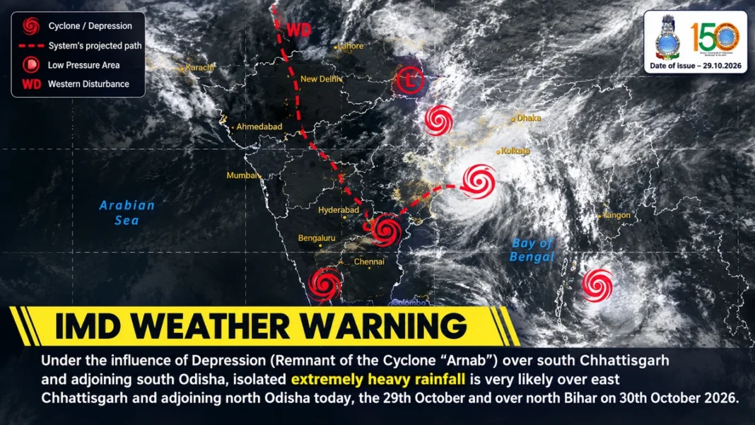
The India Meteorological Department (IMD) has warned of extremely heavy rainfall in parts of Chhattisgarh and Odisha on Thursday, October 29, with northern Bihar facing a risk of extremely heavy downpours on Friday, October 30, as the remnants of Very Severe Cyclonic Storm Arnab move inland.
In its national weather bulletin issued on Thursday afternoon, the IMD said the depression associated with the remnants of Cyclone Arnab was moving northwards across central Chhattisgarh and adjoining Odisha. The system was expected to weaken further into a well-marked low-pressure area over northern Chhattisgarh and adjoining northwestern Odisha by Thursday evening.
The weather department has warned that heavy rainfall could disrupt transport, cause waterlogging in low-lying areas and damage standing crops in affected districts.
Chhattisgarh, Odisha Face Heavy Rainfall Risk
According to the IMD’s October 29 bulletin, heavy to very heavy rainfall is likely at a few places in northern Chhattisgarh, while isolated locations could receive extremely heavy rainfall.
In Odisha, interior districts are likely to experience heavy to very heavy rainfall at several places, with extremely heavy downpours possible at isolated locations.
The IMD’s latest subdivision-wise warnings also list extremely heavy rain and thunderstorms with lightning or squally conditions for Chhattisgarh on October 29. Odisha remains under a significant rainfall warning as the system continues to influence the region.
Residents in vulnerable and low-lying areas should remain alert to possible flooding and follow instructions issued by local authorities.
North Bihar on Alert for October 30
The IMD has forecast a fresh spell of intense rainfall over northern Bihar on Friday.
While isolated locations in Bihar could receive heavy to very heavy rainfall on October 29, the department has warned that parts of northern Bihar could experience extremely heavy rainfall on October 30.
Jharkhand is also expected to receive heavy to very heavy rainfall at isolated places on Thursday, with isolated heavy rainfall likely on Friday.
The forecast indicates that the impact of Arnab’s remnants will extend beyond the immediate location of the depression, keeping several parts of eastern India vulnerable to rain and thunderstorms.
What Happened to Cyclone Arnab?
Cyclone Arnab has weakened considerably since crossing the Andhra Pradesh coast. However, its remnants continue to influence weather conditions over central and eastern India.
The IMD reported that the depression moved northwards at approximately 23 kmph during the six hours preceding its 11:30 am observation on October 29. At that time, it was centred over central parts of Chhattisgarh and adjoining Odisha, around 110 km south of Raipur.
The system was forecast to weaken into a well-marked low-pressure area later on Thursday.
Although the storm is losing strength, its remaining circulation can continue to produce substantial rainfall. Consequently, the weakening of the cyclone does not mean the immediate end of the rainfall threat.
Rainfall Already Recorded Across Eastern India
The IMD’s observations for the 24 hours ending at 8:30 am on October 29 indicated exceptionally heavy rainfall in Ganjam district of Odisha, where 54.6 cm was reported.
Extremely heavy rainfall was also recorded over coastal Andhra Pradesh and Yanam, with rainfall totals in the 21–30 cm range. Heavy rainfall was reported across parts of Gangetic West Bengal, Jharkhand, Chhattisgarh and Telangana.
These observations highlight the extent of rainfall associated with the weather system and the continuing risk of localised flooding in affected areas.
Possible Impact on Roads, Crops and Daily Life
In its national bulletin, the IMD identified several potential impacts from the forecast rainfall, including:
- Waterlogging in low-lying areas and localised urban flooding.
- Disruption to road traffic and longer travel times.
- Possible flooding of rural roads and damage to unpaved road sections.
- Damage to standing crops, plantations and horticultural produce.
- Risks associated with thunderstorms, lightning and strong or squally winds.
People travelling through affected districts should check local weather updates and road conditions before starting their journeys. Residents in flood-prone areas should avoid crossing flooded roads or flowing water.
Farmers should monitor district-level advisories for guidance on protecting standing crops and agricultural infrastructure.
Weather Outlook: October 29–30
The immediate focus remains on eastern and central India as the depression weakens and moves northwards.
On October 29, the principal rainfall concerns are northern Chhattisgarh, interior Odisha, Jharkhand and parts of Bihar, alongside other areas identified in the IMD’s national bulletin.
On October 30, northern Bihar faces a risk of extremely heavy rainfall at isolated locations. Rain and thunderstorms may also continue across parts of Odisha, Jharkhand and neighbouring regions.
The IMD continues to issue updated forecasts and warnings as the system evolves. Residents should consult the department’s official website for the latest district-wise alerts.